

Subway Map Seoul
Seoul has quite a big subway system. On the left-hand side you can see a clipping of the whole plan. This small part already shows the problem which arises when colorblind people try to decipher subway maps: There are too few well distinguishable colors which can be used for coloring.
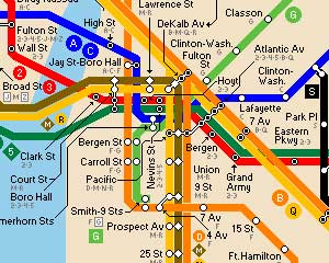
Subway Map Ney Nork
New York has the even larger subway system and therefore is a real challenge for the color department. Lines running parallel and crossing lines look often the same. This makes it hard to read. A good point: The line letters are spread over the whole map, so you can at least follow the letters.

Subway Map London
Actually it should be possible to choose different colors combined with patterns to make a subway map readable. The London tube map is not any better than the others. Sometimes similar lines are either form north to south or east to west, a slight improvement.
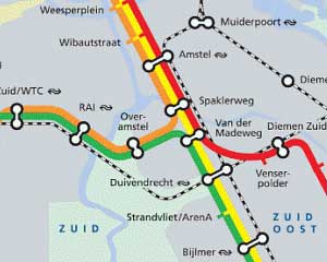
Subway Map Amsterdam
This is the very best I found. The Amsterdam subway map has only four different lines to distinguish. But still they weren’t able to choose the colors well enough. The green and orange (I hope they are green and orange) look almost the same to people affected by red-green color blindness!

Subway Map Tokyo
This map looks the most complicated. Too many lines intertwine into each other. Too many colors who should be distinguished and matched to a legend. But at least they realized the problem that such maps are not readable for colorblind passengers and put effort into improvements.
All maps were found through The Subway Page, which has an incredible list of links to subway maps from all around the world.
Related articles:
Japan’s Public Facilities Making Life Easier for Colorblind
Color Coded Power Types
Project Management by Red and Green Light
hi there,
I’ve designed a NYC subway map that takes color blindness better into account. Here’s a link to the same area in Brooklyn that you posted:
http://www.kickdesign.com/mapcomparison/pages/3_brooklyn_comparison.html
& here’s a link to the whole site:
http://www.kickdesign.com/mapcomparison
I would like to know your thoughts!
best regards, Eddie Jabbour
Eddie, just had a look at your subway map. I’m not sure: is it meant, that some lines have the same color? For me there are 3 – 4 colors well distinguishable (on my monitor). Is that, what it should be? Are there some lines copied by purpose?
Would like to hear more about it or why your doing it. Thanks anyway for stopping by.
yes. the nyc subway has multiple lines sharing the same color. for example the 4, 5, & 6 lines are all green. the A, C, E lines are all blue – and so on… the current official map makes all the same color lines into 1 line which makes it difficult to quickly scan to see what route your particular train takes…
Pingback: MaggieMaggio.com » Color Blind Design
Actually TFL (the organisation that runs london underground) has a black and white version of their map on their web site.
http://www.tfl.gov.uk/assets/downloads/bw-large-print-map-0108.pdf
Great information, I really enjoyed it!
Many metro maps are just that , metro maps but often they omnit other interlinking lines. In London the old British Rail lines. With the development of Thameslink, Crossrail and the overground these should be included and the southern system colour coded by destination srtation in London. If the underground is done in a line, the overground routes, dockland light railway and croydon tramlink in narrower double lines and the main lines (including Crossrail and Thameslink with doublewidth lines the number of colours is kept relatively low.
This is also true on the Tokyo example where the underground,Private lines and Japanese railway lines could take over the planned patterns.
I usually consult the Cyberstation to calculate how long it will take for me to travel from one station to another. My husband’s cellphone also has maps of the metropolitan cities that have subway